Existing vs As-Built Surveys – What’s the Difference?
Existing vs As-Built Surveys – What’s the Difference? Laurel Hardwicke February 20, 2026 For Architects Existing vs As-Built Surveys...

128 City Road, London
+44 20 4615 4666
hello@linesurveying.uk
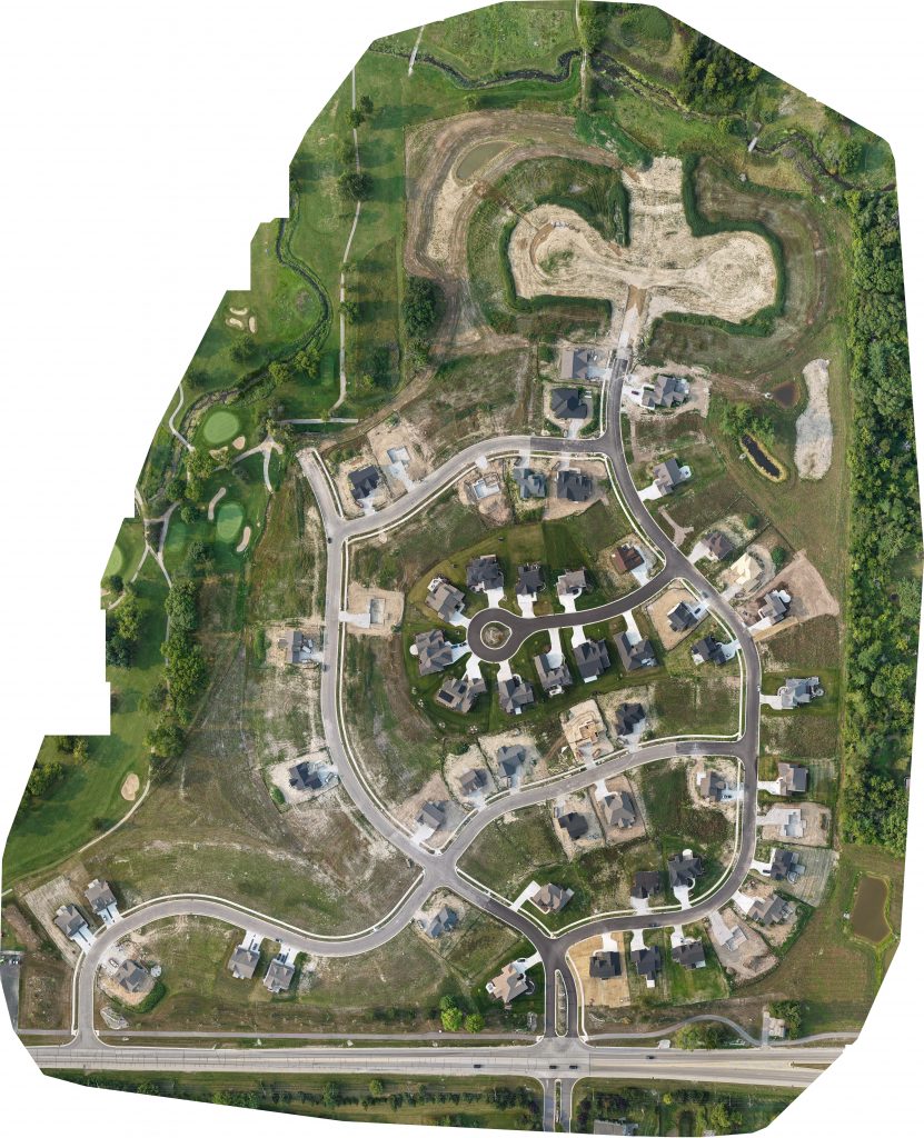
An orthomosaic map is a high-resolution aerial image created by stitching together multiple drone photographs into a single geometrically corrected, survey-accurate map. Our London orthomosaic surveys provide measurable aerial data suitable for planning applications, land analysis, construction monitoring and development projects.
Our experienced survey team combines RTK drone technology with advanced photogrammetry processing to deliver precise orthomosaic maps. Every project follows a structured workflow to ensure reliable, survey-grade aerial data suitable for:
We use RTK-enabled drone systems to achieve centimetre-level positional accuracy, producing measurable aerial imagery suitable for design and planning.
Orthomosaic maps provide a clear, measurable overview of sites for architects, planners and developers.
Accurate aerial data helps identify constraints, boundaries and site features early in the project lifecycle.
Residential land, commercial developments, construction sites and large open parcels.
Supplied in GeoTIFF, CAD (DWG) and PDF formats compatible with industry software.
1. Site Review & Flight Planning
We assess site constraints, airspace restrictions and project objectives.
2.Drone Data Capture
Automated grid flights capture high-overlap aerial imagery using RTK positioning.
3. Data Processing
Images are processed using professional photogrammetry software to create a geometrically corrected orthomosaic.
4. Quality Control
We verify alignment, scale accuracy and coordinate referencing.
5. Final Deliverables
You receive a high-resolution orthomosaic map ready for planning or design use.
Answers to common questions about how our surveys are carried out, what to expect on site and how the process works.
An orthomosaic is a geometrically corrected aerial image created by stitching together multiple drone photographs. Unlike a standard drone photo, it is measurable and suitable for survey and planning purposes.
Using RTK drone systems, horizontal accuracy can typically reach 2–3cm when supported by proper ground referencing.
Yes. Orthomosaic maps provide measurable aerial data that can support planning submissions, feasibility studies and development proposals.
We supply orthomosaic maps in GeoTIFF, DWG and PDF formats. Coordinate systems can be provided in OSGB36 or WGS84 as required.
Most orthomosaic surveys are delivered within a few working days depending on site size and complexity.
We provide professional orthomosaic mapping and drone aerial survey services throughout Greater London and surrounding areas. Our RTK drone surveys deliver high-resolution, geo-referenced aerial maps suitable for planning, development and construction projects.
Articles covering mapping, drone surveys, topographical surveys and planning guidance for London development and construction projects.
Existing vs As-Built Surveys – What’s the Difference? Laurel Hardwicke February 20, 2026 For Architects Existing vs As-Built Surveys...
Measured Surveys for Planning Applications – What’s Required? Max Hardwicke February 20, 2026 For Architects Measured Surveys for Planning...
Drone Photogrammetry for Large Residential Sites Laurel Hardwicke February 20, 2026 For Architects Drone Photogrammetry for Large Residential SitesLarge...
We use cookies to improve your experience on our site. By using our site, you consent to cookies.
Manage your cookie preferences below:
Essential cookies enable basic functions and are necessary for the proper function of the website.
These cookies are needed for adding comments on this website.
Statistics cookies collect information anonymously. This information helps us understand how visitors use our website.
Google Analytics is a powerful tool that tracks and analyzes website traffic for informed marketing decisions.
Service URL: policies.google.com (opens in a new window)
You can find more information in our Cookie Policy and .