
Existing vs As-Built Surveys – What’s the Difference?
Existing vs As-Built Surveys – What’s the Difference? Laurel Hardwicke February 20, 2026 For Architects Existing vs As-Built Surveys...

128 City Road, London
+44 20 4615 4666
hello@linesurveying.uk
At Line Surveying, we deliver high-accuracy 3D laser scanning services across London for residential, commercial and industrial properties.
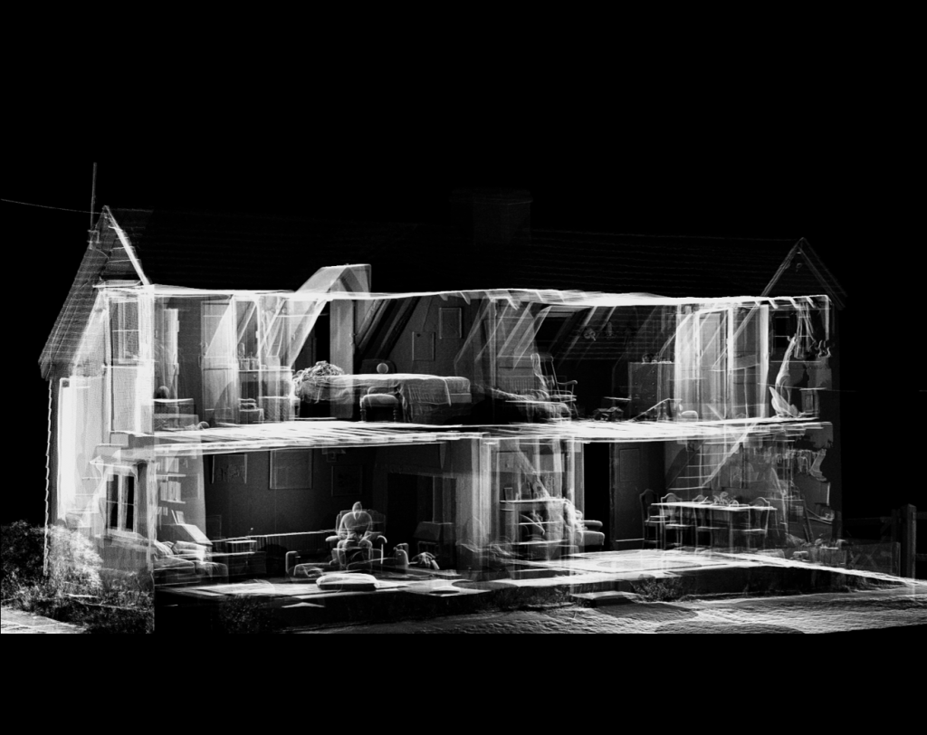
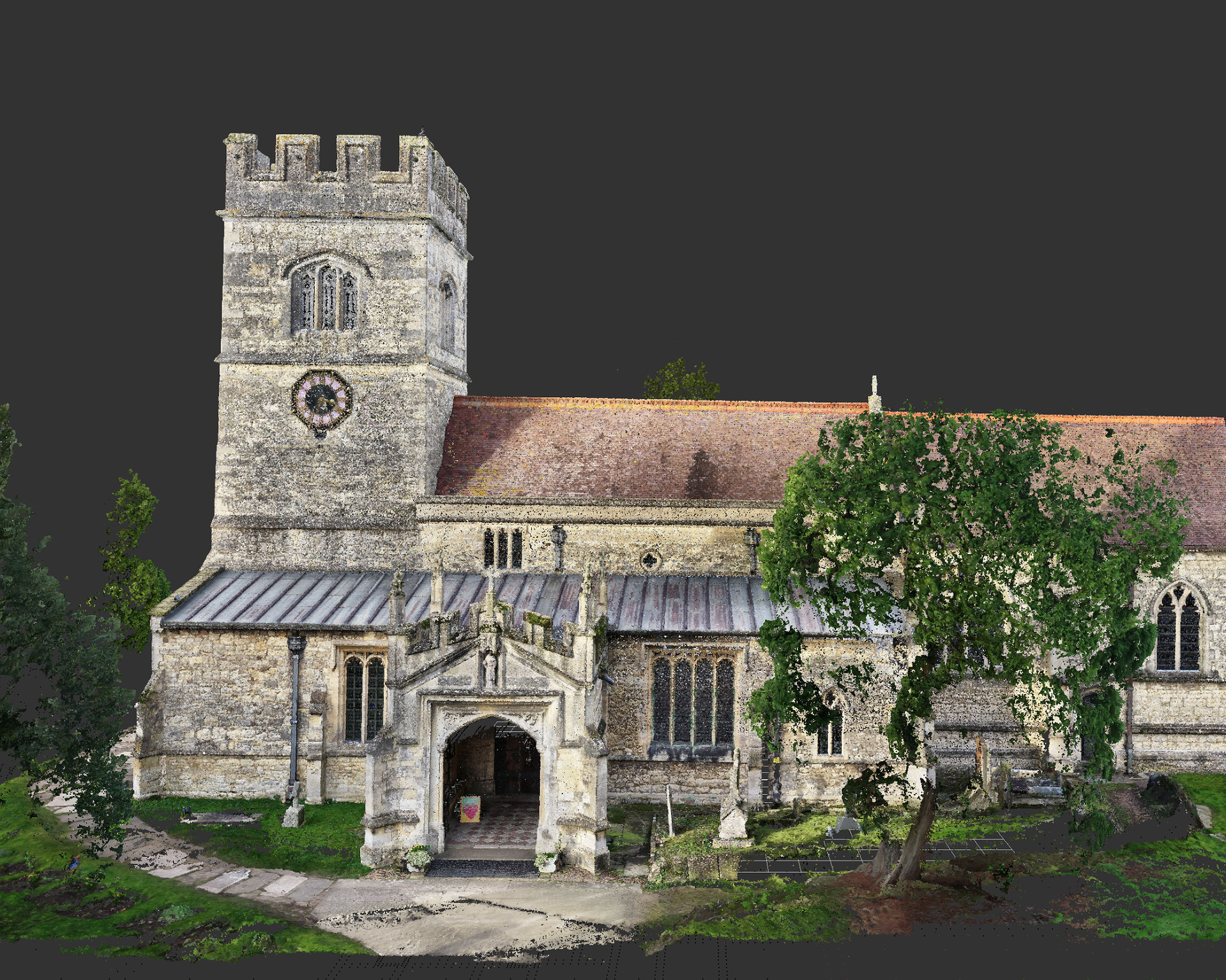
Using advanced terrestrial laser scanning technology, we capture millions of precise measurement points to create detailed point clouds, BIM models and CAD drawings suitable for architecture, design and construction projects.
Our structured workflow ensures accurate, reliable data for planning, refurbishment, redevelopment and asset management.
We combine advanced 3D laser scanning technology with professional surveying expertise to deliver precise, reliable spatial data across London.
Our experienced team follows structured survey workflows to ensure consistent, high-quality outputs suitable for:
Captures millions of measurement points to produce millimetre-level precision for detailed analysis and design work.
Large buildings and complex structures can be scanned quickly, reducing site time while maintaining accuracy.
Accurate, comprehensive data minimises return visits and costly design errors.
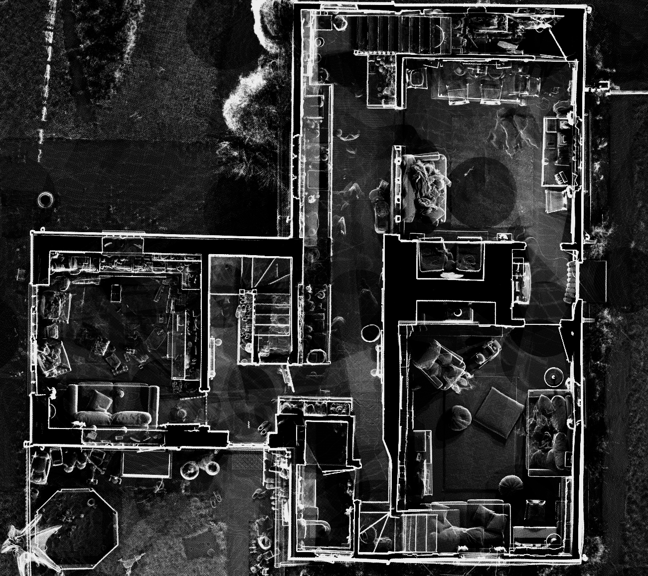
Deliver detailed 3D point clouds compatible with Revit, AutoCAD and other BIM platforms.
Scan intricate internal and external environments including plant rooms, basements and high-level features.
1. Initial Consultation
We review your project scope, required deliverables and site access constraints.
2. Site Survey & Data Capture
Using advanced laser scanning equipment, we capture millions of precise data points across the property.
3. Point Cloud Processing
Captured scan data is registered and processed to create a unified, accurate 3D point cloud.
4. Model & Drawing Production
We produce BIM models, 2D CAD drawings or Revit models based on your project requirements.
5. Delivery & Support
We provide structured digital outputs and remain available for clarification or coordination with your design team.
Answers to common questions about how our surveys are carried out, what to expect on site and how the process works.
3D laser scanning is a surveying method that captures millions of accurate spatial data points to create detailed 3D digital representations of buildings and structures.
We provide point clouds, 2D CAD drawings, Revit models and BIM-ready outputs depending on project requirements.
Laser scanning typically achieves millimetre-level accuracy, making it suitable for complex architectural and engineering projects.
Yes. We regularly undertake scanning projects for commercial, industrial and multi-storey buildings across London.
Most residential projects are completed within one day. Larger commercial sites vary depending on scale and complexity.
We provide professional 3D laser scanning and point cloud surveys across London and surrounding areas, delivering accurate BIM-ready data for residential and commercial projects.
Articles covering measured building surveys, topographical surveys, drone photogrammetry and planning guidance for London property projects.
Existing vs As-Built Surveys – What’s the Difference? Laurel Hardwicke February 20, 2026 For Architects Existing vs As-Built Surveys...
Measured Surveys for Planning Applications – What’s Required? Max Hardwicke February 20, 2026 For Architects Measured Surveys for Planning...
Drone Photogrammetry for Large Residential Sites Laurel Hardwicke February 20, 2026 For Architects Drone Photogrammetry for Large Residential SitesLarge...
We use cookies to improve your experience on our site. By using our site, you consent to cookies.
Manage your cookie preferences below:
Essential cookies enable basic functions and are necessary for the proper function of the website.
These cookies are needed for adding comments on this website.
Statistics cookies collect information anonymously. This information helps us understand how visitors use our website.
Google Analytics is a powerful tool that tracks and analyzes website traffic for informed marketing decisions.
Service URL: policies.google.com (opens in a new window)
You can find more information in our Cookie Policy and .