Existing vs As-Built Surveys – What’s the Difference?

128 City Road, London
+44 20 4615 4666
hello@linesurveying.uk
Max Hardwicke
February 20, 2026
If you’re preparing a planning application, an accurate measured survey forms the foundation of your entire project. Without precise drawings of the existing building, planning authorities cannot properly assess the proposed changes.
Because planning decisions are based on scale, height and relationship to surrounding properties, submitting clear and dimensionally accurate information is essential. This guide explains what measured surveys are required for planning applications and how to ensure your submission meets approval standards.
A measured survey — also known as a measured building survey or existing building survey — provides a detailed and accurate record of a property’s current layout and dimensions.
Using advanced measurement technology, surveyors capture on-site data and produce scaled drawings that reflect the building exactly as it exists.
These drawings typically include:
Existing floor plans
Elevations
Cross sections
Roof plans
Site layout drawings
Internal room layouts
Window and door locations
Structural components
As a result, architects can confidently design extensions, loft conversions, refurbishments and commercial developments based on reliable information.
Planning authorities assess applications based on several key factors, including:
Scale
Massing
Height
Relationship to adjacent buildings
Impact on the street scene
If existing drawings are inaccurate, proposed drawings will also be incorrect. Consequently, this often leads to:
Requests for additional information
Delays in processing
Resubmission of applications
Increased professional costs
For this reason, an accurate measured survey significantly reduces planning risk and improves approval timelines.
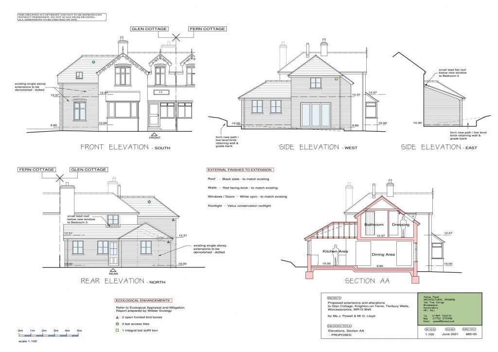
Although requirements vary between councils, most planning applications require the following existing drawings:
Usually prepared at a scale of 1:50 or 1:100.
Showing all sides of the property, including accurate:
Ridge heights
Eaves heights
Ground levels
Indicating:
Boundary locations
Access points
Surrounding context
Prepared by your architect using the measured survey as the foundation for the design.
In particular, accurate ridge and gutter levels are essential for extensions and loft conversions, as planners assess height and visual impact carefully.
A planning survey must be:
Correctly scaled
Dimensionally accurate
Clear and legible
Consistent between existing and proposed drawings
Today, measured surveys commonly utilise:
3D laser scanning
Point cloud surveying
Drone roof surveys
This technology captures precise height data, roof pitches and structural details that would otherwise be difficult to measure manually. Therefore, modern survey methods provide a far higher level of accuracy than traditional tape-based measurement.
In some cases — particularly for larger developments or new builds — a topographical survey may also be required.
A topographical survey provides:
Site levels
Boundary positions
Tree and vegetation locations
Drainage features
Adjacent highway information
Your architect or planning consultant will advise whether this is necessary. However, arranging the correct surveys at the outset prevents delays later in the process.
Ideally, a measured survey should be arranged before any design work begins.
Doing so ensures:
Architects work from verified dimensions from day one
Planning drawings are accurate
Structural engineers receive reliable information
Costly re-measurements are avoided
Ultimately, it is far easier — and more cost-effective — to obtain accurate data at the start than to correct drawings later.
Planning applications require accurate existing drawings
Measured surveys form the foundation of proposed designs
Laser scanning and drone surveys improve accuracy
Inaccurate drawings can delay approval
Early surveying reduces risk and additional cost
At Line Surveying Limited, we specialise in delivering accurate measured building surveys using 3D laser scanning and drone technology.
Our measured surveys include:
Existing floor plans
Existing elevations
Existing sections
Existing roof plans
CAD and PDF deliverables
If you are preparing a planning application, we ensure your architect has precise and reliable information to design with confidence.
Contact us today to discuss your measured survey requirements.
We use cookies to improve your experience on our site. By using our site, you consent to cookies.
Manage your cookie preferences below:
Essential cookies enable basic functions and are necessary for the proper function of the website.
These cookies are needed for adding comments on this website.
Statistics cookies collect information anonymously. This information helps us understand how visitors use our website.
Google Analytics is a powerful tool that tracks and analyzes website traffic for informed marketing decisions.
Service URL: policies.google.com (opens in a new window)
You can find more information in our Cookie Policy and .