Existing vs As-Built Surveys – What’s the Difference?

128 City Road, London
+44 20 4615 4666
hello@linesurveying.uk
Max Hardwicke
February 20, 2026
Accurate design begins with dependable information. In construction and refurbishment projects, even minor measurement errors can cause redesign work, programme delays and increased costs. For this reason, point cloud data has become a critical tool for architects and engineers.
Through 3D laser scanning, surveyors capture millions of precise coordinate points. As a result, designers work from real site conditions rather than assumptions. Consequently, drawings align more closely with existing geometry from the outset.
At Line Surveying UK, we deliver high precision point cloud data that supports accurate design workflows across London and the UK.
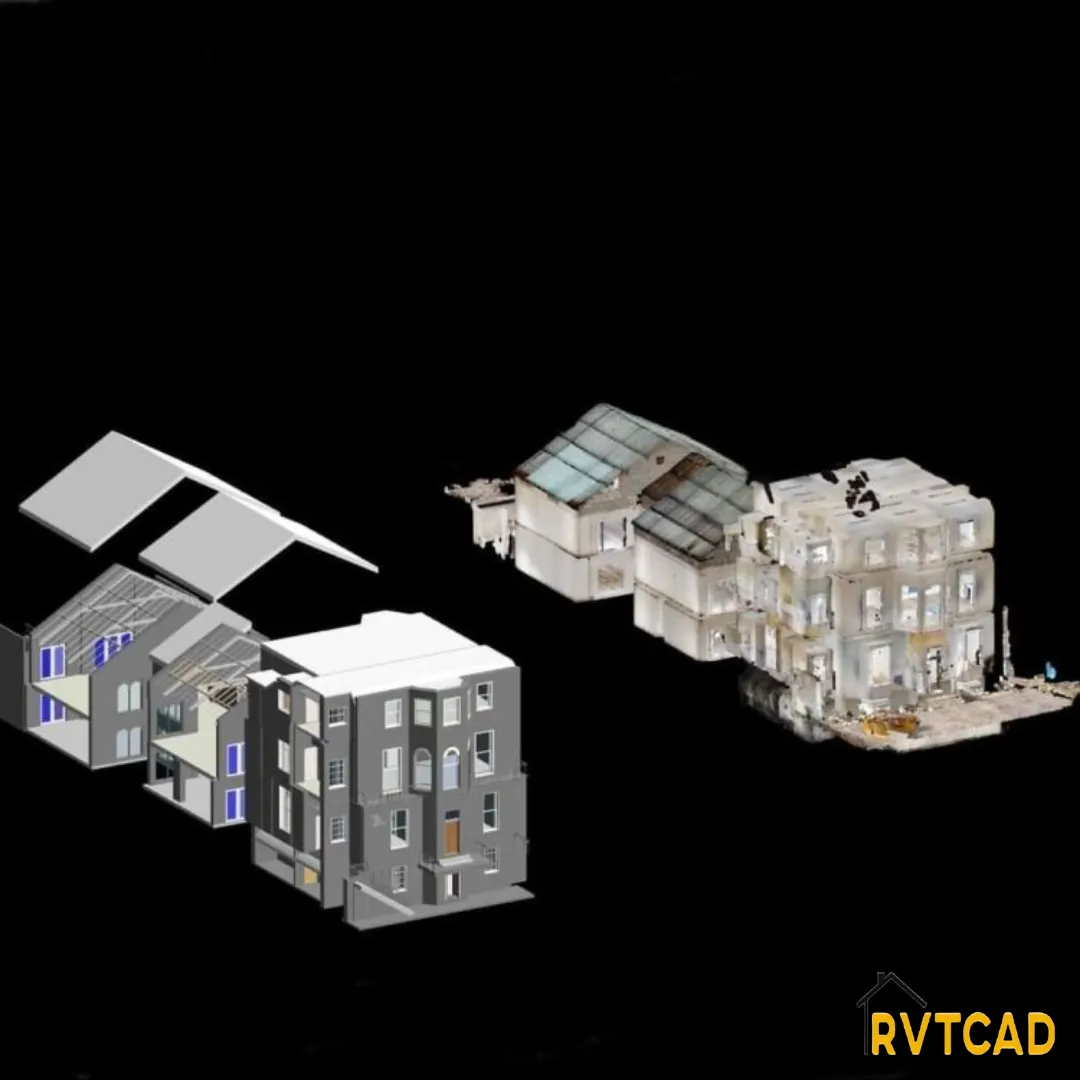
Point cloud data is generated using advanced laser scanning technology. During the scanning process, equipment records millions of points in three dimensional space. Together, these points create a detailed digital representation of a building or site.
Once processed, the dataset can be imported into AutoCAD, Revit and other modelling platforms. In turn, designers can trace over real geometry to produce reliable drawings. Because the information reflects actual conditions, confidence in the design increases significantly.
Measurement inaccuracies are one of the most common causes of design problems. Traditional manual methods may overlook subtle variations in wall alignment, floor levels or structural elements. However, laser scanning captures consistent geometry across the entire space.
As a result, point cloud data helps prevent:
Misaligned walls
Incorrect floor heights
Inaccurate window and door openings
Structural coordination clashes
With accurate baseline information established early, design revisions become far less likely.
Refurbishment projects often involve irregular layouts and complex construction details. In these cases, assumptions can quickly lead to conflicts between new and existing elements.
By contrast, point cloud data captures complex geometry in full detail. Therefore, architects can design around existing features with greater certainty. This is particularly important in heritage buildings, where preserving original fabric is essential.
Successful delivery depends on effective collaboration between architects, structural engineers and building services consultants. When each discipline works from different base information, inconsistencies appear.
Instead, a shared point cloud dataset provides a single reliable reference. Structural supports align correctly with architectural layouts. Similarly, service routes can be positioned to avoid clashes with ceilings and beams. As coordination improves, overall project efficiency increases.
Modern design workflows rely heavily on BIM and 3D modelling. Point cloud data integrates directly into Revit and similar platforms, allowing teams to build models over precise scanned geometry.
As a result, spatial relationships become clearer. In addition, level coordination improves. Furthermore, detailing accuracy increases. Because the digital model reflects true site conditions, construction risk reduces significantly.
Accurate design directly influences build quality. When dimensions are correct, fabricated components fit as intended. Likewise, reliable level data ensures drainage systems function properly. Consequently, contractors spend less time making adjustments on site.
Ultimately, point cloud data strengthens both design accuracy and construction performance.
The effectiveness of point cloud modelling depends entirely on scan accuracy. Professional laser scanning and careful registration ensure dependable results.
At Line Surveying UK, we provide accurately processed point cloud datasets tailored to architectural and engineering workflows. Because our data integrates seamlessly into AutoCAD and Revit environments, design teams can move forward with confidence.
Yes. Laser scanning captures millions of coordinate points, which significantly improves positional accuracy compared to manual measurement.
Yes. Even smaller refurbishment and extension projects benefit from precise digital site information.
Point cloud data typically forms part of a measured building survey. Together, they provide comprehensive and reliable information about existing conditions.
If you are planning a refurbishment, extension or new build project, accurate point cloud data will improve design precision and coordination.
Contact Line Surveying UK to discuss your project and receive high accuracy survey data tailored to your requirements.
We use cookies to improve your experience on our site. By using our site, you consent to cookies.
Manage your cookie preferences below:
Essential cookies enable basic functions and are necessary for the proper function of the website.
These cookies are needed for adding comments on this website.
Statistics cookies collect information anonymously. This information helps us understand how visitors use our website.
Google Analytics is a powerful tool that tracks and analyzes website traffic for informed marketing decisions.
Service URL: policies.google.com (opens in a new window)
You can find more information in our Cookie Policy and .